Even though today people have various electronic devices, they still live a full life, going hiking, climbing mountains, and so on. But even here the technologies have improved the area. In the past making measurements of altitude and pressure required a lot of special tools that were heave to carry on.
Now with our gadgets, we can find out the altitude on any point of the Earth by a simple click on the smartphone screen. All we have to do is to choose the best elevation app which would suit our tastes the most.
Make the necessary measurements using these best altimeter elevation apps.
Accurate Altimeter
This is the most popular app for measuring altitude on Google Play and we couldn’t agree more – it is truly efficient. Thanks to this application you can estimate the altitude by three accurate methods. The app works offline, i.e. without an internet connection.
You can track the altitude based on smart charts that simulate the change of your route during excursions.
Also the app has interactive maps with the names of the peaks and contour lines. You can track elevation from any point on this map.
The outputs of the app systems are also supported by photos with the name of the marking place and the calculation of the altitude above sea level.
Altitude can also be estimated with a pressure sensor built into your device. All readings are correlated to the pressure of the nearest weather station for increased accuracy.


You may also like: 15 best compass apps for Android & iOS
My Altitude
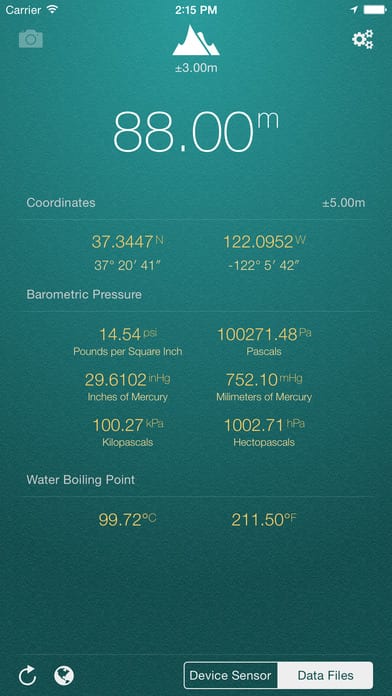
This app is used for determining your location too. When you want to know your altitude (height from sea level), barometric pressure, and water boiling point you just launch My Altitude. The best thing it doesn’t require an Internet connection to start working. It best works outdoors.
You can detect your altitude at your current position or find a certain location on the map or the location where you have been to and measure its height. It is essential to know that the newer your device is, the more accurate your measurements will be.
Another fun option here is that you can take a picture of where you are at the moment and save it to the album. The picture will be saved with all the coordinates from the app, along with altitude and local date/time.
Barometric Pressure is calculated based on elevation. All in all, you will stay aware of the situation around you while making trips.

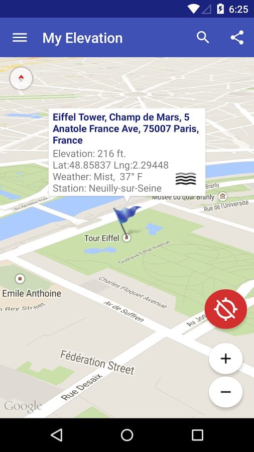
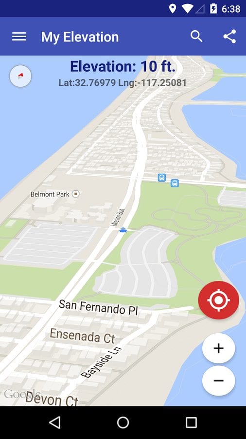
My Elevation
This app uses a web connection to precisely detect your location by any means. Then it will detect your elevation. This is for those who consider that data from the Internet is more precise than those measurements that your device can do.
The application shows the surface elevation above sea level based latitude and longitude. Remember, that when you are in the aircraft or somewhere high above the ground the app will be unable to detect your elevation.
You have to be connected to the Internet in order to receive all the necessary data about your location. Otherwise, the app will not work.
You can choose to Follow Me mode and the app will be detecting details of your locations all the way along as you walk. What is more, you can search for a certain location and the app will show the weather there and also bring you some details from Wikipedia about that place.
For those, who like to explore places from distance this option will be really curious. You can click on a location on the map and the app will show you the closes attractions nearby. Then, if you want, you can see the street panorama of places and share your locations via social networks.
inRoute
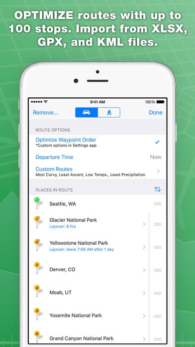
With this app, you can plan any route safely and confidently. It will measure the distance, elevation, weather, etc.
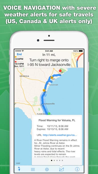
There is also a navigator with the voice which tells you where to turn while making your journey. You can also check your route for severe weather. If there is information that the weather is going to be dangerous then you will get an alarm.
The app gives you the possibility to create your own routes based on your preparations and settings, such as distance, elevation, time, and so on. Interactive charts show route elevation, curviness, weather (temperature, humidity, precipitation, wind speed/direction, severe weather alerts).
It also shows the time of sunrise and sunset.
Moreover, you can always find some amenities near a particular point marked by you. If you liked the route that you have completed then save it to your favorites in the app. Set the time of departure and arrival, check the conditions and you are ready to go.
Altimeter GPS
This app will help you find out the level of your location above the sea. Measuring altitude with maximum accuracy will be useful for those who prefer to climb high elevations, mountains, and so on.
To get accurate data, you need to give permission to automatically connect geolocation while using the service. Then the device will synchronize with the satellites and give accurate information about the altitude at which you are.
You can also get data about the minimum and maximum altitude that you were able to reach. The data will be presented in a table.


Travel Altimeter & Elevation
It is not so easy to find a good altimeter app for iPhone, but this one seems to be quite good and does what it says it does. First of all, it is remarkable for its magnificent design and multifunctionality. Travel Altimeter has not only an elevation meter but other meters as well, though, let’s keep everything in order.
First of all, make sure that your iOS device is one of the latest versions for precise measurements. By taking into consideration the barometric pressure and GPS location, Travel Altimeter will provide you with the data about the current elevation status – and it’s going to be quite precise information.
And if you don’t believe us, you can read the comments that support this opinion. What is more, a nice feature of this app is that it allows the creation of wallpapers with the perpetuated altitude – a nice option for travelers and travel bloggers. The app can create topographical maps.
Apart from measuring the altitude, you can also check the latitude and longitude, choose the type of metrics and use the built-in flashlight. One more little thing that we want to mention is that the app is customizable and by acquiring the in-app purchases you can choose its background.


You may also like: 16 Best GPS Apps for Android
Altimeter & Altitude Widget
This app is designed for altitude measurement, altitude logging, and mapping. The application is also a widget. In addition to displaying and tracking your altitude, with this app you can find altitude for any location.
The app provides several sources with which you can select data. You can select information from the NASA Shuttle Radar Topography Mission or U.S. Geological Survey. However, this feature is only available in the United States, southern Canada and Mexico.
The app is easy to use, the interface and design will allow you to quickly understand the settings and easily find the information you need.


GPS Altitude Elevation
You don’t want to get lost? Or do you think it’s worth periodically fixing your coordinates during a hike or when climbing a mountain?
The GPS Altitude Elevation calculates your exact location and gives you an estimate of your altitude. Of course, up to a centimeter of accuracy, no one promises you, but the data is roughly accurate.
You can send your coordinates by email or SMS to your friends or yourself. The text that you see in the picture can be easily customized, formatted, or copied. In the settings, you can also adjust the refresh rate of your GPS coordinates.
The accuracy of your location depends on the signal strength. If you are connected to a Wi-Fi network, you will not be able to see the altitude you are at.
The accuracy of the calculation of coordinates in rooms is lower than on the open surface, this should be considered. When you’re hiking and conquering new summits and GPS Altitude Elevation routes, you need to let your friends and family know where you are and keep them informed.


GPS Location and Elevation
Another altitude and elevation measurer for Android devices might be not the best app in this category, but still, we recommend paying attention to it. The thing is it uses your GPS data and synchronizes this with the satellite maps, providing quite an accurate elevation measurement.
The interface design couldn’t be plainer here, so all those who value beautiful aesthetics are better to go for another app. When you open it the first thing you do is give this GPS Location and Elevation access to your data, so be careful about it. On the other hand, the app finds your location immediately along with determining the elevation.
Short and informative instructions are an advantage of this app – they don’t mess with your using the app but at the same time they are always there if you need a guide. And on the other hand, one of the biggest drawbacks of this app is the abundance of ads.
In the menu on the left, you can choose various types of maps, whether it’s one from a satellite or a terrain view. Moreover, you can add locations to the “saved” section. By the way, there is a “Pro” version available in the app in case you don’t want to watch ads all the time.


Compass & Altimeter
If you are a fan of travel and wildlife, don’t forget to install the Compass & Altimeter app. It will help you navigate even in unfamiliar terrain and without help. The app does not require a constant Internet connection to work fully. You can use it even in the most remote corners of the world.
A handy electronic compass will tell you the exact coordinates and altitude. Latitude and longitude are presented in convenient MGRS, DMM, and UTM formats. Get accurate information about sunrise and sunset times. Choose one of the suggested themes to make the compass dial bright and stylish.
The accuracy of the information obtained is high and equates to the performance of modern equipment. If possible, use the app outdoors to reduce magnetic interference. Avoid phone cases that have magnetic parts.


You may also like: 15 Free GPS tracking apps for Android & iOS
Altimeter
A handy and useful app for determining true altitude (MSL). Pixelprose SARL offers you their service for the greatest comfort. The Altimeter mobile app helps you quickly and accurately determine the MSL value at the point where you are. You will not depend on your Internet connection.
The app works even in flight mode. Besides, you can get similar information about any geographical object. Before you start, you need to allow access to your location. In its work, the app uses the Earth model EMG96, which makes it possible to get reliable information.
Besides altimeter, the service works as a barometer and GPS navigator. Simple functionality allows determining the real altitude in a few clicks. The program was installed by more than 500 thousand users. Get accurate results of your location absolutely free.