Area measurement can be a struggle and cost quite a lot of money. But did you know you can measure land by simply walking through it?
Take a look at our list of best land measurement apps by walking (Android & iOS) that could ease your life. These apps let you measure routes and areas by tracking your GPS info. You’ll just need to walk around the required area and the accurate measurements will be ready right away. Let’s dive in!
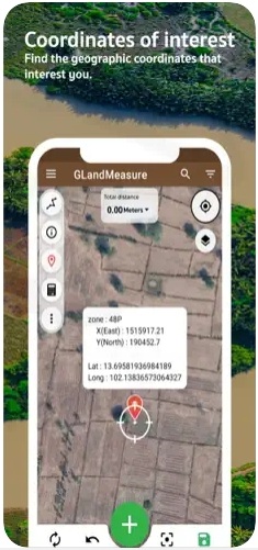
GLandMeasure
It’s a simple app that lets you measure lands by walking.
In fact, the app uses two calculating methods for you to try. First, there’s a walking one. All you need to do here is to give the app access to your GPS tracking, get to your starting point, and start measuring. You may rather use this method to calculate distances or areas, it will work nicely both ways.
Along with that, there’s a map measuring way where you need to add pins on the map. The app uses a detailed 3D map you can zoom in and rotate to place the pin accurately. The pins can be used to create shapes and routes, so no worries here. You can also switch map views from classic to satellite, hybrid, and terrain.
The app also covers numerous map layers such as WMS, rain, and so on. Plus, you can use several length units and automatically convert pre-made results. You can save as many projects as required with no limits. You can also save projects as docs or share them with one tap.


You may also like: 15 Best Measure Distance Apps
GPS Fields Area Measure
That’s an area measurement app that supports the walking method.
Sooth to say, this app is one of the most popular choices when it comes to land measurement. It lets you measure land, routes, and perimeters with ease. Just like the previous one, this app covers both maps and walking counting ways. As for the map one, you’ll just need to mark the area on the map and the app will automatically count it for you.
The app provides you with several instruments like a regular pen or smart pins, so choose the one you like most. There’s also an undo button, so you won’t mess anything up. Plus, you can easily measure lands and distances by simply walking and driving through it.
Of course, it’s way more simple to use the walking method for route measures, but you can cope with the land one as well. The amount of measures is unlimited, and you can save and store as many projects as needed. You can also sort and group your projects and edit them at any time.


Distance And Area Measurement
Here’s a minimalist app that lets you calculate lands with minimum effort.
If you’re looking for an app that is fully dedicated to walking measurements, this is the one. Walking is the only way for you to measure distances here, and the app gets the job done with it. The mechanic is pretty simple: first, you need to give the app access to track your GPS data.
Then, once you’ll get to the starting point of your measurement, press start and wait for the GPS tracker to stabilize. The positioning may be a bit shaky at the beginning, make sure to reboot the calculation if it happens.
You’ll get to measure distances and lands of any length, the tracking time is not limited. Plus, you can always pause the measurement if needed. The app supports various length units that you can adjust at any time needed.


Check also: 11 Free Landscape Design Apps
Area Calculator For Land
That’s a smart area calculator tool you can use without extra skills.
It covers two ways of land measuring, and you can easily switch between them depending on the type of your measures. The manual walking mode lets you count distances and lands by tracking your location info. Just turn on the app, press start, and move around the area you need to be measured.
The walking mode has 2 sec dealt, so you can check if you haven’t made any mistakes. Of course, you can edit the route after finishing it, so no worries here. The default length unit is m2, but you can convert the measurements to multiple other formats with one tap.
Beyond that, you can measure land by simply adding pins to the map. You can search for any location or address and place as many pins as required. The app lets you edit pre-made projects at any time, and you can zoom in on the map and change the view angle to place pins more accurately.


Land, Fields and Area Measure
It’s a calc app that lets you count areas by walking.
It’s a handy measuring tool that is completely user-friendly and accessible to everyone. The walking mode works simply. All you need to do is to start measuring and walking around the area you want to measure. The app will track your location till the app is turned on, so make sure not to close it.
The app lets you save multiple projects and edit them at any time, so you can always adjust the measure if smth goes wrong. As for the map counting method, it’s even more simple than the walking one. You’ll get to add points to the map and connect them to the shape of the required area.
The minimum number of pins is 3 and the maximum is not limited. You can use these ways or measure both lands and distances, so you’re all the way covered. The app supports various length units for you to switch, and you can save projects as doc files for easy sharing.


Step Tracker – Pedometer
The “Step Tracker” app is a fitness application designed to help users track their daily steps and monitor their physical activity levels. Developed by an unknown developer, this app offers a simple and straightforward way for users to keep track of their steps and set fitness goals.
One of the key features of the Step Tracker app is its ability to accurately count and record the number of steps taken by the user throughout the day. Using the device’s built-in accelerometer or GPS technology, the app tracks the user’s movements and converts them into step counts.
To use the Step Tracker app, users need to download and install it from the Google Play Store. Once installed, they can open the app and start tracking their steps immediately. The app displays the user’s step count in real-time, allowing them to monitor their progress throughout the day.
In addition to step tracking, the app may also offer other features such as distance traveled, calories burned, and activity history. Users can set daily step goals and receive notifications when they reach their targets, helping them stay motivated and committed to their fitness routine.
Overall, the Step Tracker app provides a convenient and accessible way for users to monitor their physical activity levels and stay active throughout the day.


Step Counter
The “Step Counter – Pedometer, Calorie Burner, Step Tracker” app is a versatile fitness tool developed to track users’ physical activity and help them achieve their health and fitness goals. Created by unknown developers, this app offers various features to enhance users’ fitness journey.
While the primary focus of the Step Counter app is on tracking steps and monitoring daily physical activity, it also offers a unique capability to measure land by walking with the app.
Users can utilize the app’s GPS functionality to measure distances while walking around the perimeter of the area they want to measure. The app then calculates the total distance walked, providing users with an accurate measurement of the land area covered.
To use the app for land measurement, users need to download and install it from the Google Play Store. Once installed, they can open the app and select the “Measure Land” feature. Users then walk along the perimeter of the land they wish to measure, and the app automatically calculates the distance covered.
In addition to land measurement capabilities, the Step Counter app offers other interesting features such as calorie tracking, step goal setting, activity history, and real-time step tracking. Users can also view detailed statistics and graphs to track their progress over time, making it a comprehensive tool for fitness enthusiasts.


You may also check: 11 Best Square Footage Apps
Geo Measure Area Calculator

And lastly, there’s an area measurement calculator you can use on the go.
Just like the previous one, this app features two ways of measurement: manual and GPS. The manual mode lets you measure lands and distances by adding parkers on a detailed 3D map. You can zoom the map in and try various view modes if needed. You can also alter the view angle to place the markers with more accuracy.
The app comes with an undo button and lets you adjust the position of markers at any time. Besides, you can measure areas by recording your PGS data. At that point, you just need to start recording and walk by the route or around the area you want to measure.
You can save all the measurements and store the projects within the app. Plus, you can load the file with pre-made calculations if needed. All the projects can be saved as KML files and shared via messengers.


