There are many reasons for needing a land measurement tool — you may be buying a new property or planning to build something on your land. Whatever your purpose is — this article has you covered.
There are lots of property lines apps for Android and iOS that empower you to make any land calculations fast and easy. These apps can quickly give you any info about the property you need — from the owner’s name to its lines. Besides, these apps have different measuring modes so there’s something for everyone.
In case you need apps for distance measuring, check out this article: 17 Best Measure Distance Apps for Android & iOS
Here’s the list of the 9 best apps in that category you should try. Have a look!
LandGlide
Let’s start with an app called LandGlide. This is an app that empowers you to view your property lines.
The app runs on GPS tech to track your current location and enables you to explore the surrounding map. Frankly speaking, you can not only view the surrounding map — the app covers more than 100 million property documents in over 3,000 counties. To be more precise, for now, the app covers 95% of the US map.
Plus, the app has a sleek minimal interface that is incredibly easy to use. Basically, you just need to tap on the property you want to explore and the app will show you the owner, the exact address, the lines, ID, price, and more. In case you wonder if it is legal to provide users with such data the answer is yes.
Beyond that, the app empowers you to save the property you viewed and even pin your own notes to it.
Another cool thing about this app is that it grants you to save all the info about any property as a document and export it on your phone or tablet. You can even do it without having an Internet connection which is great.


You may also check: 12 Best tape measure apps for Android & iOS
GPS Fields Area Measure
GPS Fields Area Measure is another app that will help you quantify any fields on the map and view their borders.
The main goal of this app is that it is bundled with useful features while being extremely easy to use. The app enables you to gauge fields, the distance between the points, and count the perimeter. Therewith, there are not many efforts required from you and everything can be done in a couple of secs.
All you need to do is to place the points around the property and the app will take care of the rest. And if you’ll place any point in the wrong place you can always change that. In case you need to determine the surrounding area you can turn on your GPS data.
You can also zoom in on the map to place the pinpoints in the most accurate way. There’s even a smart marker more that automatically marks blocked areas like fields or individual buildings.
All the areas you measure can be saved to your profile for a quick reach out. Besides, you can export all the data in a doc form on your device even if you’re offline.


GIS Surveyor – Land Survey and GIS Data Collector
GIS Surveyor is a land survey app that will help you to get all the measurements of your (or somebody else’s) property.
This app is made for GIS data management, its survey, analysis, and more. In other words, this app will get you all the detailed data about your land without much effort from you.
Plus, the app runs on GPS tech so you can quickly measure the areas near you. Although the app can do lots of stuff its interface is still pretty clear and easy to work with.
Let’s talk about how to measure something in this app. When you’ll find the property you want to measure on the map you’ll need to point a pin on it and mark all the lines.
Once it’s done you can make all the measurements — the area, the perimeter, and so on. Plus, you can count the distance between two points on the map. Therewith, you can place the points as you want including the dioramas.
On top of that, you can save the info about any areas on your profile for quick access. Plus, the app will provide you with all the data it has about the property- from the owner to its current sale price. You can also export any info as a doc and share it via emails.


Geo Survey – Land Survey
First, I’d like to highlight the app’s key functions. You can quickly find the distance, area, and angles on land with an iPhone or iPad.
Plus, it lets you save and share your survey results in different formats, which is great for passing along to others or to clients.
And with GPS tech, you measure things spot-on with your gadget. Just launch it, pick either distance, area, or angle for measuring, and then do what the screen says. You can drop pins on the map to measure.
Or, if you want, use augmented reality to see distances right as they happen. It’s like a land surveyor that fits right in your pocket!
Geo Survey: Land Survey aims to make land surveying easy. It helps users get precise land data measurements. If you’re measuring your backyard, planning a building as an architect, or a pro surveyor needing a quick tool, this app is for you.


Geo Measure Area Calculator
Geo Measure Area Calculator is an app that empowers you to explore various field data for free. This app is practically a field estimation tool that enables you to view the lines of the property and count its area and perimeter.
The app runs on GPS so you can quickly view the info on the surrounding lands. Therewith, the app has two modes of property determinations.
The first one is manual measurement. As its name suggests this mode aims you to mark the property you want to measure on your own.
Wherein, you can zoom the map to get the most accurate property lines. Once all the boundaries are marked you can pick what kind of measurements you want to do and the app will take care of the rest.
The second mode is the GPS one. As you can guess, the app will track your location here. When you’ll turn on the mode the app will start recording your position.
And all you need to do here is to move around to point out the area you want to quantify. Once it’s done — click the “stop recording” button and pick the measurements. All the results can be exported as a document o your device.


GPS area measure – land survey
GPS area measure is an app that will help you to figure out your land’s size. This is another land survey application that empowers you to find out the size and the perimeter of any property or area. Although the app’s interface might be quite confusing at first it’s actually pretty easy to use.
So to start the measuring process you’ll need to click on the “GPS walk” button and start walking across the land. Once you’ll get over that, click on the “calculate” button and pick the type of measurements you want to do. And if you want to get all the possible data at once — pick the overall report option.
In case you’ll face many obstructions on your way, just press pause to not crush the measuring process.
Another thing that needs to be mentioned is your last position on the map will automatically attach to the first one so it’s not necessary to close the area.
When all the quantifies are done you can export the data on your device in a document form or just save it in your acc. The app can also convert the units automatically if needed.


Check also: 11 Best House Hunting Apps for the USA
Area Calculator For Land – GPS Area Measurement
Area Calculator For Land is a smart measurement tool that empowers you to view all the parameters of your land.
Along with the previous app, this one also uses the GPS tech that empowers you to make measurements by simply walking around your property. It might not be the most convenient way if you need to measure somebody else’s land but there’s a good-old manual map mode for that.
As for the walking mode, it requires an Internet connection (obviously) and automatically counts the area and the perimeter when you click on the “calculate” button. Therewith, it’s not necessary for you to walk over your whole property — the app will automatically connect your first and last position on the map.
The manual mode works simple — you place the pins on the area you want to measure and the app takes care of the rest. Wherein, you can zoom the map to get all the borders correctly. Once everything is calculated you can save the results to your account or load it to your device as a PDF file.


Distance & Area Measure
Distance & Area Measure is an app that will measure the area of the land and its lines. The main goal of this app is to make the measuring process easy and accessible for all people. That’s why it has easy to use interface that doesn’t require any special abilities from users.
Plus, the app has three map modes — the normal one, the satellite one, and the hybrid one. It also uses your GPS so you could easily view the surrounding areas.
Speaking of how to actually make measurements in this app. All you need to do is to place pins around the area you want to quantify. Therewith, you can zoom the map and switch its angle to get the most accurate results.
In case you’ll put the pin in the wrong place you can easily remove it or change its location. Once the area is marked you can pick any measurement you need and the app will do it in secs. Then, the app can convert the distance and area units if needed. You can also save the reports at your acc or load them to your device.


AndMeasure (Area & Distance)
And lastly, AndMeasure is a land survey app that empowers you to calculate the areas of properties along with their borderlines.
This app has various tools so there are lots of ways to use it. For instance, you can use the map ruler tool to count the distance between multiple points. You can also place pins on the map to calculate the area and the perimeter of the land.
Next, you can convert both distance and area units if needed. On top of that, the app runs on your location and there are several ways to use it too.
To be more precise, it empowers you quickly view the surrounding areas. Plus, you get to measure the distance to your current GPS position from multiple spots at the same time.
The app also has several map modes so you can pick the one that matches your preferences. You can also save the calculations for any data to your account for easy access or load it on your phone as a document.


Map Area Calculator – Marea
The cornerstone of this app is its ability to measure the area of any shape on a map. Planning a hike? Figuring out your garden size? Assessing a field’s dimensions? This app handles it all. It streamlines the task, freeing you from complex manual work.
MAREA’s graphics are sleek. The app shows a map that lets you draw shapes by tapping and dragging. As you draw, it calculates the area instantly. This makes it easy to see and grasp what you’re working on.
Pick the map you need, like Google Maps or OpenStreetMap. Next, draw the shape you’re looking at measuring. That’s it! The app quickly shows you the area.
MAREA makes measuring areas on maps simple and precise. Forget tedious hand calculations or rough estimates. A few clicks are all you need with MAREA to measure spaces accurately. It’s suitable for casual users as well as experts in fields such as land surveying or architecture.
Map Area Calculator is a helpful tool for those who often measure map areas. It’s easy to use, looks good, and makes the task quicker and easier.


Parceled – Real Estate
Parceled is an app developed to support users in determination the exact parcel lines of any land, using GPS coordinates and satellite images.
Users input an address or GPS coordinates and are then presented with a satellite image of the land in question.
From there, users can draw lines on the image to create an outline of the property or use the app’s automated tools to generate a more accurate depiction of the property lines.
Parceled’s satellite images are crisp and clear, making it easy to identify landmarks and other features of the land. However, some users have noted that the app can be slow to load images or that the images may not be up-to-date.
However, you can be upset by a lack of functions. Additionally, some users have reported issues with the app crashing or freezing, though these reports are relatively rare.
Advantages:
- Helps users identify and visualize property lines.
- Offers accurate and up-to-date mapping data.
- Provides an easy-to-use interface for navigation and measurements.
Drawbacks:
- Limited to certain geographic locations.
- May not always reflect legal property boundaries.


My Family – GPS Tracker for me
To start, it affords the possibility to simply include all your relatives in the app and establish a personal network. It empowers you with the ability to observe their immediate whereabouts on a map, undoubtedly cool.
Furthermore, you are enabled to get notifications when a family member enters or departs a specific zone, a feature that boosts comfort and safety.
Let’s dive into the image quality of this program. Navigating through the map section is a breeze. A single tap lets you juggle between the whereabouts of distinct relatives.
This app’s objective is to boost family security and dialogue. You can watch your kids when they’re outdoors or just want to confirm your family’s safety, the app has it all. You’ll feel less worried, knowing you can quickly find and talk to your loved ones as necessary.
Alright then! The app My Family GPS Tracker for Me is a superb tool that ensures you can trace and stay in touch with your family.


You may also like: 12 Best Home Renovation Apps (Android & iOS)
HuntStand: GPS, Maps & Tools
It offers highly precise maps of hunting zones, a real boon when you’re out in nature. It has a weather function that provides you with current weather information, wind direction, and phases of the moon to help optimize your hunting strategy.
There’s the option to personalize markers and waypoints, and you even have the ability to sketch out the borders of your own hunting areas on the map.
You can identify preferred hunting locations, follow individual hunts, and even log crucial details like animal sightings or results from trail cameras. Moreover, a community-focused feature lets you network with fellow hunters, exchanging advice, pictures, and experiences.
The main purpose of this application is to boost your hunting adventures. Regardless if you’re an experienced hunter or a newcomer, HuntStand will assist in maximizing your hunting ventures.
Therefore, it provides all necessary components for organizing and implementing fruitful hunting outings.


The Regrid Property App
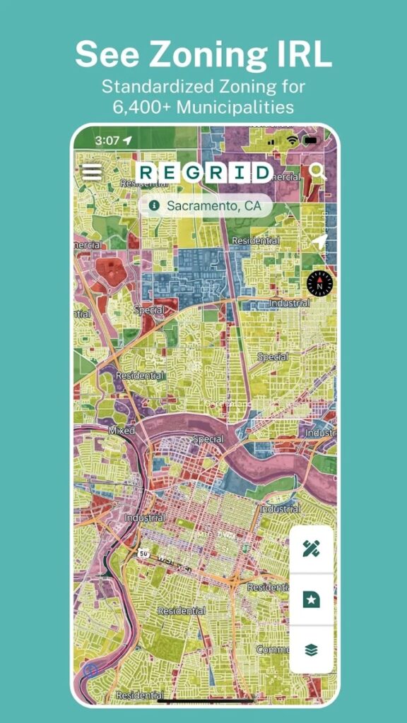
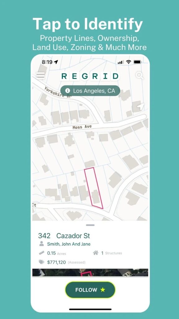
egrid Property App gives you instant access to detailed property data for over 157 million parcels across the U.S., covering 99% of the population. Perfect for homeowners, real estate professionals, or anyone curious about land and property details!
What Can You Do with Regrid?
Tap to Explore
Get key property details with a tap—lot lines, boundaries, owner info, address, acreage, square footage, land use, zoning, property history, and more!
Interactive Map Views
Switch between street and satellite views for a clear picture of any property.
Search Made Easy
Find properties by address or location, and share links for collaboration or quick reference.
Simple Sign-Up
Sign up with just your email and enjoy unlimited access to nationwide public property data.
Upgrade to a Pro account for advanced tools and features at Regrid.com. Start exploring properties like never before—download Regrid Property App today!


